- Home Page /
- Books /
- Travel /
- Europe /
- Spain /
- General /
- Northern Spain: Camino de Santiago Map (Natio...

Item #:
56399558
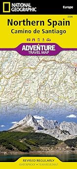
Northern Spain: Camino de Santiago Map (National Geographic Adventure Map, 3306)
Item #:
56399558
IMP 21
Price Details
Excluding Shipping & Custom charges ( Shipping and custom charges will be calculated on checkout )
*All items will import from US
0 ratings
Write a review
In stock
QTY:
Order now and get it around Friday, July 10
Secured transaction
Ubuy works hard to protect your security and privacy. Our advanced payment security system ensures confidentiality by encrypting your information during transmission using AES (Advanced Encryption Standards) and SSL (Secure Socket Layer) protocols. Your payment details are 100% secure as we do not share your payment details with third party sellers.
Our Top Logistics Partners
National Geographic Adventure Maps are perfect for pre-trip planning and on the ground navigation. Waterproof, tear-resistant, and nearly indestructible, these maps are the essential travel tool for domestic or international travel.
Fast
Shipping
Free
Return*
Secure Packaging
100% Original Products
PCI DSS Compliance

ISO 27001 Certified
Note: Step Down Voltage Transformer required for using electronics products of US store (110-120). Recommended power converters Buy Now.


What Stands Out
Detailed Navigation
This folded map provides extensive details on the Camino de Santiago route, ensuring travelers can navigate easily through the scenic trails of Northern Spain with clear markings of key locations.
Durable Material
Made from high-quality, tear-resistant paper, this map is designed to withstand the rigors of outdoor use, making it the ideal companion for pilgrims seeking adventure on the iconic Camino de Santiago.
User-Friendly Design
The user-friendly layout includes points of interest, accommodation options, and essential facilities, empowering adventurers to enhance their journey with valuable local insights and travel tips.
Product Details
| Item Weight | 0.2 lbs (90 grams) |
Who Should Buy?

-
Hikers and Pilgrims
Ideal for those walking the Camino de Santiago, offering essential details about trails, accommodations, and landmarks.
-
Adventure Travelers
Perfect for adventure seekers looking to explore Northern Spain's unique landscapes and cultural sites with comprehensive navigation.
-
Outdoor Enthusiasts
Great for anyone interested in outdoor activities such as hiking, biking, or discovering scenic routes and natural beauty.

-
City Tourists
Not suitable for travelers mainly focusing on urban exploration or city-centric attractions away from the Camino.
-
Digital Nomads
Less useful for those who prefer digital maps and apps for navigation rather than traditional paper maps.
-
Infrequent Travelers
Not ideal for casual travelers who rarely explore or may not need detailed maps for short trips.
Product Description
Northern Spain: Camino de Santiago Map (National Geographic Adventure Map, 3306)
Have any Query? Chat with us
Customer Questions & Answers
-
Question:
What are the main features of the Northern Isle of Man: Camino de Santiago Map?
Answer: The Northern Isle of Man: Camino de Santiago Map by National Geographic offers detailed topographic coverage of the Camino de Santiago route, highlighting key landmarks, towns, and natural features along the way. It includes elevation profiles, suggested itineraries, and practical travel tips to enhance your experience. This makes it an essential tool for pilgrims and travelers who want to navigate the scenic trails, discover local culture, and engage with the historical significance of the route. -
Question:
Is this map suitable for seasoned hikers and casual walkers alike?
Answer: Absolutely! Whether you are a seasoned hiker or a casual walker, the Northern Isle of Man: Camino de Santiago Map is designed to cater to various skill levels. It provides detailed elevation information and trail conditions, which can help experienced hikers plan their journey, while offering straightforward directions and points of interest for those looking for a more relaxed walking experience. This versatility ensures that all adventurers can enjoy the breathtaking landscapes and the rich history of the Camino. -
Question:
Can I use this map for navigation without any additional tools?
Answer: Yes, the Northern Isle of Man: Camino de Santiago Map is specifically crafted to be a standalone navigation tool. It features clear markings of trails, roads, and waypoints, making it easy to follow even without electronic devices. Travelers can rely on the map for accurate distances and route guidance. Many users find that having a physical map enhances their experience by helping them engage more deeply with their surroundings, allowing them to navigate while also enjoying the journey. -
Question:
Does the map include information about accommodations and services along the route?
Answer: Yes, this map includes valuable information about various accommodations, food services, and facilities available along the Camino. You'll find icons and annotations that point to hostels, hotels, and restaurants, making it easier for travelers to plan their stops. Understanding where to rest and refuel is crucial for anyone hiking, especially on longer segments of the route, ensuring you can enjoy a comfortable experience while taking in the beautiful surroundings. -
Question:
Can this map help in planning my itinerary for the Camino de Santiago?
Answer: Absolutely! The Northern Isle of Man: Camino de Santiago Map is an excellent resource for planning your itinerary. It outlines the major routes, distance between towns, and estimated hiking times, allowing you to customize your journey based on your fitness level and time constraints. Users often take advantage of the suggested itineraries provided, ensuring they can make the most of their pilgrimage while experiencing both the spiritual and cultural aspects of the Camino. -
Question:
Is the map durable enough for outdoor use?
Answer: Yes, this map is designed for durability, often laminated or printed on waterproof materials for outdoor use. This resilience means it can withstand various weather conditions and repeated handling during your travels. Hikers frequently appreciate its durability, especially in the unpredictable climates of Northern Isle of Man, where rain and moisture can be common along the Camino, ensuring your map remains intact and usable throughout your journey. -
Question:
What is the scale of this map, and how does it help in planning hikes?
Answer: The Northern Isle of Man: Camino de Santiago Map typically features a scale that allows for precise measurements of distance, which is vital for planning hikes. A common scale is 1:75,000, meaning that 1 cm on the map corresponds to 750 m in real life. This scaling helps hikers gauge distances accurately, making it easier to determine how long specific sections will take to traverse, allowing for effectively planned hiking stretches each day. -
Question:
Does this map highlight cultural and historical sites along the way?
Answer: Yes, the map not only focuses on the trails but also highlights numerous cultural and historical sites that you can visit along the Camino de Santiago. These can include ancient churches, ruins, and other points of historical interest. Travelers can better appreciate the significance of their journey by using the map as a guide to explore these enriching locations, enhancing their pilgrimage experience with deeper cultural insights. -
Question:
What should I keep in mind when using this map on my journey?
Answer: When using the Northern Isle of Man: Camino de Santiago Map, it's important to regularly check your surroundings, as trail markers can sometimes be sparse. Carrying the map alongside a compass or other navigation tool is advisable, especially in more remote areas. Additionally, hikers should remain aware of local weather forecasts and trail updates to ensure a safe and enjoyable experience along the Camino, maximizing both enjoyment and safety on your adventure. -
Question:
Where can I buy Northern Isle of Man: Camino de Santiago Map in Isle of Man?
Answer: You can purchase the Northern Isle of Man: Camino de Santiago Map at Ubuy. Ubuy provides a convenient online shopping experience, ensuring you can find this detailed map easily. Browse through their website for availability and additional options, making everyone’s pilgrimage a memorable and well-prepared journey.
General Editorial Review
The Northern Spain National Geographic Adventure Map is a high-quality, detailed map that features locations of interest, lodgings, ATMs, bridges, and more. It is made of durable material, but some customers have suggested it would be even better if printed on plastic. According to one user, locating areas of interest can take a bit of effort as different areas of Spain's Camino trails are on both sides of the map. Another reviewer pointed out that the title is slightly misleading, and the map only covers Northwest Spain and does not include Barcelona or the north of Barcelona. Overall, customers were pleased with the product's quality and level of detail, with one stating it is the only map you will need for traveling in this region. National Geographic's reputation for producing exceptional maps was reinforced by several customers who praised the paper quality and durability of the product.
Customer Reviews & Ratings
1 customers ratings
-
5 Star
100%
-
4 Star
0%
-
3 Star
0%
-
2 Star
0%
-
1 Star
0%
Review this product
Share your thoughts with other customers
Pros
- Detailed map with locations of interest, lodgings, ATMs, bridges, etc.
- Made of durable, high-quality material
- Easy to read and packed with information
- National Geographic's reputation for producing exceptional maps
Cons
- Some customers have suggested printing the map on plastic for added durability
Product Price History
Important information
- Limitations : For products shipped internationally, please note that any manufacturer warranty may not be valid; manufacturer service options may not be available; product manuals, instructions, and safety warnings may not be in destination country languages; the products (and accompanying materials) may not be designed in accordance with destination country standards, specifications, and labeling requirements; and the products may not conform to destination country voltage and other electrical standards (requiring use of an adapter or converter if appropriate). The recipient is responsible for assuring that the product can be lawfully imported to the destination country. When ordering from Ubuy or its affiliates, the recipient is the importer of record and must comply with all laws and regulations of the destination country.
- Not all the products listed on Ubuy are for sale, as Ubuy is a global search engine. Products are subject to export/trade regulations.
IMP 21
Order now and get it around Friday, July 10
This item is not restrict in my country.(Please click on above link if this item is not restrict in your country, So our team will review and allow.)
QTY:
Secured transaction
Ubuy works hard to protect your security and privacy. Our advanced payment security system ensures confidentiality by encrypting your information during transmission using AES (Advanced Encryption Standards) and SSL (Secure Socket Layer) protocols. Your payment details are 100% secure as we do not share your payment details with third party sellers.
Our Top Logistics Partners
Fastest cross-border delivery
Features & Benefits
- Perfect for pre-trip planning and on the ground navigation
- Waterproof, tear-resistant, and nearly indestructible
- Clean cartographic design for easy navigation
- Ideal for domestic or international travel
- Featuring detailed road networks, key points of interest, and UNESCO World Heritage sites
- Supports the National Geographic Society with every purchase